![](/images/other/stat-length.png)
![Tour Wandern Le Puy-Sainte-Réparade - Messidor Le Puy Ste Réparade Fonscolombe grande boucle - Photo](https://media.geolcdn.com/t/1900/400/d52e5f05-c5eb-4a49-972b-2f4e9e17f157.jpg&format=pjpeg&maxdim=2)
Messidor Le Puy Ste Réparade Fonscolombe grande boucle
jll7513
Benutzer
![Länge](/images/other/stat-length.png)
Länge
10,9 km
![Maximale Höhe](https://static1.geolcdn.com/siteimages/upload/files/1508320355ic_sort_altitude_max_24dp.png)
Maximale Höhe
255 m
![Positive Höhendifferenz](https://static1.geolcdn.com/siteimages/upload/files/1508320355ic_sort_den_pos_24dp.png)
Positive Höhendifferenz
109 m
![Km-Effort](/images/other/stat-length.png)
Km-Effort
12,4 km
![Min. Höhe](https://static1.geolcdn.com/siteimages/upload/files/1508320355ic_sort_altitude_min_24dp.png)
Min. Höhe
191 m
![Negative Höhendifferenz](https://static1.geolcdn.com/siteimages/upload/files/1508320355ic_sort_den_neg_24dp.png)
Negative Höhendifferenz
110 m
![Boucle](https://static1.geolcdn.com/siteimages/upload/files/16400158638029165_repeat_loop_refresh_sync_direction_icon.png)
Boucle
Ja
Erstellungsdatum :
2021-06-25 03:35:28.0
Letzte Änderung :
2022-05-16 08:20:48.788
![Wandern](https://static1.geolcdn.com/sitytour/trail-icons/101.png)
2h48
Schwierigkeit : Einfach
![Nordic Walking](https://static1.geolcdn.com/sitytour/trail-icons/102.png)
1h57
Schwierigkeit : Einfach
![Scannen Sie diesen QR-Code, um die Tour in der SityTrail-Anwendung zu öffnen](https://capi.geolives.com/qq0zvz2zws4bq2lad0pu/sitytour/trails/2838444/qr.png?size=200)
Kostenlosegpshiking-Anwendung
Über SityTrail
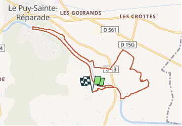
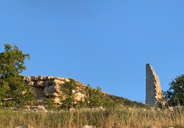
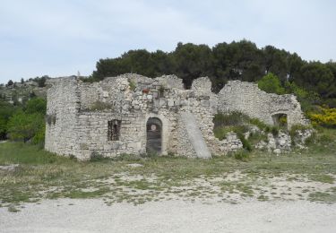
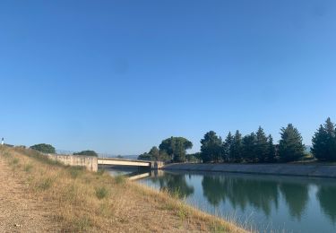
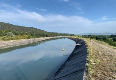
Tour Wandern von 10,9 km verfügbar auf Provence-Alpes-Côte d'Azur, Bouches-du-Rhône, Le Puy-Sainte-Réparade. Diese Tour wird von jll7513 vorgeschlagen.
Beschreibung
J'ai commencé la randonnée depuis le camping messidor. Mais elle peut être faite depuis la route où il y a possibilité de garer son véhicule à côté de l'abribus. Trajet sympa sur le bord du canal puis au milieu des vignes.
Ort
Land:
France
Region :
Provence-Alpes-Côte d'Azur
Abteilung/Provinz :
Bouches-du-Rhône
Kommune :
Le Puy-Sainte-Réparade
Standort:
Unknown
Gehen Sie:(Dec)
Gehen Sie:(UTM)
698064 ; 4835174 (31T) N.
Kommentare
Touren in der Umgebung
![Tour Wandern Le Puy-Sainte-Réparade - La Quiho - Saint Canadet - Photo](https://media.geolcdn.com/t/375/260/ext.jpg?maxdim=2&url=https%3A%2F%2Fservices.sitytrail.com%2FGeolivesWS%2FDownloadMedia.ashx%3FTrailID%3D107616%26Media%3D12588_6.jpg)
![Wandern Wandern](https://static1.geolcdn.com/sitytour/trail-icons/101.png)
La Quiho - Saint Canadet
Wandern
Einfach
(2)
Le Puy-Sainte-Réparade,
Provence-Alpes-Côte d'Azur,
Bouches-du-Rhône,
France
![](/images/other/stat-length.png)
8,8 km | 12 km-effort
4h 0min
![](https://static1.geolcdn.com/siteimages/upload/files/16400158638029165_repeat_loop_refresh_sync_direction_icon.png)
Ja
![Tour Wandern Le Puy-Sainte-Réparade - st Canadet- la quille - Photo](https://media.geolcdn.com/t/375/260/2cae01e4-2495-4b2f-aad6-3b83712f34be.jpg&format=jpg&maxdim=2)
![Wandern Wandern](https://static1.geolcdn.com/sitytour/trail-icons/101.png)
st Canadet- la quille
Wandern
Schwierig
(1)
Le Puy-Sainte-Réparade,
Provence-Alpes-Côte d'Azur,
Bouches-du-Rhône,
France
![](/images/other/stat-length.png)
10,1 km | 13,6 km-effort
2h 13min
![](https://static1.geolcdn.com/siteimages/upload/files/16400158638029165_repeat_loop_refresh_sync_direction_icon.png)
Ja
![Tour Wandern Le Puy-Sainte-Réparade - Puy Ste Réparade camping Messidor La Quille retour par canal - Photo](https://media.geolcdn.com/t/375/260/3dfedd47-cb85-40d8-ab26-092de907e2c7.jpg&format=jpg&maxdim=2)
![Wandern Wandern](https://static1.geolcdn.com/sitytour/trail-icons/101.png)
Puy Ste Réparade camping Messidor La Quille retour par canal
Wandern
Einfach
Le Puy-Sainte-Réparade,
Provence-Alpes-Côte d'Azur,
Bouches-du-Rhône,
France
![](/images/other/stat-length.png)
8 km | 11 km-effort
2h 29min
![](https://static1.geolcdn.com/siteimages/upload/files/16400158638029165_repeat_loop_refresh_sync_direction_icon.png)
Ja
![Tour Wandern Le Puy-Sainte-Réparade - Le puy Sainte Réparade, la Quille, retour par le canal. - Photo](https://media.geolcdn.com/t/375/260/4e631edc-0e75-4ec1-9786-fd08fd698ab1.jpg&format=jpg&maxdim=2)
![Wandern Wandern](https://static1.geolcdn.com/sitytour/trail-icons/101.png)
Le puy Sainte Réparade, la Quille, retour par le canal.
Wandern
Einfach
(1)
Le Puy-Sainte-Réparade,
Provence-Alpes-Côte d'Azur,
Bouches-du-Rhône,
France
![](/images/other/stat-length.png)
10 km | 13,4 km-effort
3h 2min
![](https://static1.geolcdn.com/siteimages/upload/files/16400158638029165_repeat_loop_refresh_sync_direction_icon.png)
Ja
![Tour Zu Fuß Le Puy-Sainte-Réparade - St Canadet - la Quille - chapelle Ste Reparade - Photo](https://media.geolcdn.com/t/375/260/ext.jpg?maxdim=2&url=https%3A%2F%2Fstatic1.geolcdn.com%2Fsiteimages%2Fupload%2Ffiles%2F1545311037marcheuse_200dpi.jpg)
![Zu Fuß Zu Fuß](https://static1.geolcdn.com/sitytour/trail-icons/100.png)
St Canadet - la Quille - chapelle Ste Reparade
Zu Fuß
Sehr leicht
(1)
Le Puy-Sainte-Réparade,
Provence-Alpes-Côte d'Azur,
Bouches-du-Rhône,
France
![](/images/other/stat-length.png)
8,7 km | 11,5 km-effort
Unbekannt
![](https://static1.geolcdn.com/siteimages/upload/files/16400158638029165_repeat_loop_refresh_sync_direction_icon.png)
Ja
![Wandern Wandern](https://static1.geolcdn.com/sitytour/trail-icons/101.png)
PF-Le Puy-Sainte-Réparade - Saint Canadet - La Quilho
Wandern
Einfach
Le Puy-Sainte-Réparade,
Provence-Alpes-Côte d'Azur,
Bouches-du-Rhône,
France
![](/images/other/stat-length.png)
7,9 km | 10,9 km-effort
2h 23min
![](https://static1.geolcdn.com/siteimages/upload/files/16400158638029165_repeat_loop_refresh_sync_direction_icon.png)
Ja
![Tour Wandern Le Puy-Sainte-Réparade - Le Puy Ste Réparade promenade à Fonscolombe - Photo](https://media.geolcdn.com/t/375/260/4480fe58-d32b-4860-b9f7-8398bdf3bbc8.jpg&format=jpg&maxdim=2)
![Wandern Wandern](https://static1.geolcdn.com/sitytour/trail-icons/101.png)
Le Puy Ste Réparade promenade à Fonscolombe
Wandern
Einfach
Le Puy-Sainte-Réparade,
Provence-Alpes-Côte d'Azur,
Bouches-du-Rhône,
France
![](/images/other/stat-length.png)
6,4 km | 7,2 km-effort
1h 38min
![](https://static1.geolcdn.com/siteimages/upload/files/16400158638029165_repeat_loop_refresh_sync_direction_icon.png)
Ja
![Tour Wandern Le Puy-Sainte-Réparade - Messidor (le Puy Ste Réoarade) Fontscolombe petite boucle - Photo](https://media.geolcdn.com/t/375/260/92a94be3-a7b5-47e0-b733-212c36c36aa5.jpg&format=jpg&maxdim=2)
![Wandern Wandern](https://static1.geolcdn.com/sitytour/trail-icons/101.png)
Messidor (le Puy Ste Réoarade) Fontscolombe petite boucle
Wandern
Medium
Le Puy-Sainte-Réparade,
Provence-Alpes-Côte d'Azur,
Bouches-du-Rhône,
France
![](/images/other/stat-length.png)
6,8 km | 7,8 km-effort
1h 45min
![](https://static1.geolcdn.com/siteimages/upload/files/16400158638029165_repeat_loop_refresh_sync_direction_icon.png)
Ja
![Tour Wandern Le Puy-Sainte-Réparade - la quille. j.f. marie - Photo](https://media.geolcdn.com/t/375/260/9aedfcb8-95f8-4281-a979-af97d97ed2c5.jpg&format=jpg&maxdim=2)
![Wandern Wandern](https://static1.geolcdn.com/sitytour/trail-icons/101.png)
la quille. j.f. marie
Wandern
Sehr leicht
Le Puy-Sainte-Réparade,
Provence-Alpes-Côte d'Azur,
Bouches-du-Rhône,
France
![](/images/other/stat-length.png)
13,1 km | 17,4 km-effort
3h 32min
![](https://static1.geolcdn.com/siteimages/upload/files/16400158638029165_repeat_loop_refresh_sync_direction_icon.png)
Ja